
Exploring the rocky landscapes of the north on foot
Limestone pinnacles, forest and hidden caves
From the viewpoints, you can see how closely the grey rock pinnacles stand together. Between them lie gorges and patches of vegetation. Even on a single walk, Ankarana’s landscape changes: one stretch leads through forest, another alongside the limestone formations.
The protected area is in the Diana region of northern Madagascar, between Antsiranana and Ambilobe. Its eastern entrance at Mahamasina is on the RN6. Often referred to as Ankarana National Park, it is officially a special reserve. We choose your walk according to the terrain, your interests and how much time you want to spend on foot.
MahamasinaEastern access on the RN6
Tsingy and cavesLimestone scenery and dry forest
Special reserveProtected since 1956
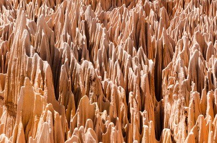
Two different places to visit
Ankarana and the Red Tsingy are separate destinations
Ankarana’s tsingy are sharply sculpted limestone formations. Over a long period, water has created fissures, gorges and caves in the rock. The pinnacles are part of a larger karst system, with underground areas that are largely hidden from view.
The Red Tsingy are a separate excursion destination in the Antsiranana area. Their reddish erosion formations are often mentioned alongside Ankarana, but they are not part of the same walking route. If you would like to see both landscapes, we allow for two visits and the journeys between them.
What would you like to explore more closely?
A walk for views over the limestone pinnacles differs from a longer cave visit. Suspension bridges are not part of every route, either. Tell me what appeals to you and what you would prefer to leave out.
Choosing your route
Three ways to explore Ankarana
The park authority lists several routes, from shorter visits to long combinations. These examples show how limestone scenery, caves and suspension bridges can fit into a walk.
Tsingy Meva and the bat cave
Limestone formations and a cave visit
About 2–3 hours
Classed as moderate by the authority.
Tsingy Rary, Tourelles and Perte des Rivières
Rock formations and the place where water disappears underground
About 3 hours
Classed as easy by the authority.
Suspension bridges, Tsingy Rary and Perte des Rivières
A longer combination with bridge crossings
About 4–5 hours
Classed as moderate by the authority.
The times and grades are published by Madagascar National Parks. “Easy” does not necessarily mean flat or suitable for everyone. We consider heat, sure-footedness, breaks and local conditions. Access to individual caves and trails is checked for your visit.
Making your walking day more comfortable
Water, good footwear and time for breaks
Allow for the heat
Exposed stretches of rock offer little shade. Bring enough drinking water, a hat and sun protection. An early start and planned breaks can help you enjoy the day at an unhurried pace.
Pay attention to the ground
Shoes with a good grip are useful on uneven and sometimes sharp limestone. When choosing the route, we discuss how much walking you want to do and whether heights, narrow passages or bridges suit you.
Discuss cave visits beforehand
Bring a head torch if your visit includes a cave. The local guide explains the route and rules. If you are uncomfortable in dark or confined spaces, we take that into account from the start.
Planning access around the season
Mahamasina in the east, Andrafiabe in the west
Mahamasina is the starting point for many visits. The village is on the RN6 between Antsiranana and Ambilobe. Your day needs to include travel and your next overnight stop as well as the walk itself. Staying nearby can make the schedule more relaxed.
Access differs between the two sides
The authority describes the eastern visitor area as accessible throughout the year. For the west, reached via Andrafiabe, it lists July to November. This helps with initial planning, but rainfall, road conditions and individual trails still need to be checked for your dates. A western excursion is therefore not automatically part of a visit starting in Mahamasina.
On a longer northern itinerary, you can combine Ankarana with other nature destinations. We allow separate stages for Montagne d’Ambre and a stay on Nosy Be.
Looking closely and visiting respectfully
A wildlife habitat and a place of cultural importance
Dry forest grows between the rocks, with more sheltered woodland in the gorges. Lemurs, birds and reptiles live in the reserve, while caves provide habitat for bats. Which animals you see cannot be predicted. It is worth stopping regularly to look and listen.
The massif and some of its caves have particular cultural importance for the Antakarana people. The advice of local guides is therefore part of your visit. Ask before taking photographs at sensitive places, and keep your distance from wildlife and cave formations.
Since the 2023 extension, Ankarana has been part of the UNESCO World Heritage property “Andrefana Dry Forests”. Its forest and limestone landscapes are protected together. Visitors must be accompanied by an approved local guide.
Questions about visiting Ankarana
Is Ankarana a national park or a reserve?
Its official name is Réserve Spéciale d’Ankarana, or Ankarana Special Reserve. Travel descriptions often also use “Ankarana National Park”. Both refer to the protected area between Antsiranana and Ambilobe.
Do I have to cross a suspension bridge?
No. Bridge crossings are not part of every listed route. If you prefer to avoid heights, we choose your visit accordingly. The exact walk is agreed with the local guide.
How much time should I allow?
According to the authority, the three routes shown here take roughly two to five hours. Travel, breaks and the return or onward journey also need time. A long walk and several other excursions cannot simply be squeezed into the same day.
Can I visit Ankarana during the rainy season?
The authority describes the eastern area as accessible all year. This does not mean that every path or cave is always open. We check access separately, especially for the west and after heavier rain.
Do I need a guide?
Yes. The authority requires an approved local guide. We agree on the route and arrange the visit for your dates. Your trip planning and support from Lemur Tours are in English; we also discuss any language preference for local guiding.
Ankarana at your own pace
Which side of Ankarana would you like to explore?
Tell me your possible travel dates and how much walking you would enjoy. Are you most interested in the tsingy, a cave or a route with suspension bridges? Together, we can find a visit that suits your interests and your journey through the north.